
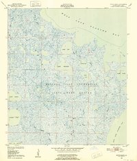
1957 Map of Bayou Sale
USGS Topo · Published 1957About this map
St Mary Parish and Iberia Parish meet at this coastal intersection of industry and wild marshland. The landscape is defined by the Intracoastal Waterway Gulf and a complex network of canals like the Hanson Canal and Thorgeson Canal, which supported the region's energy and transport needs. Inland from West Cote Blanche Bay, the Bayou Sale Oil Field and Bayou Carlin Oil Field indicate the mid-century's intensive petroleum development. Small clusters of habitation such as South Bend, Ellerslie, and Gordy line the banks of Bayou Sale, where the South Bend Cem provides a point of genealogical interest. To the west, the Russell Sage Foundation State Game Refuge on Marsh Island preserves the natural state of the gulf coast, while a line of demarcation between salt and fresh marsh tracks the shifting ecology of the Louisiana shore.
Find a feature on this map
43 named features on this map. Tap any name to fly to it.
Don’t see what you’re looking for? This feature index may not catch every label — zoom into the map to look around manually.
Map Details
Editions of this 1957 Bayou Sale Map
This is the sole edition of this map. No revisions or reprints were ever made.
Other maps of this area

1932 · Bayou Blanc
USGS Topo · 1:31,680

1935 · Belle Isle
USGS Topo · 1:31,680

1937 · Bayou Sale
USGS Topo · 1:62,500

1937 · Jeanerette
USGS Topo · 1:62,500

1937 · Derouen
USGS Topo · 1:62,500

1941 · Belle Isle
USGS Topo · 1:62,500

1945 · New Orleans
USGS Topo · 1:250,000

1948 · Foster
USGS Topo · 1:62,500
1948 · Bayou Blanc
USGS Topo · 1:24,000

1949 · Cypremort Pt
USGS Topo · 1:31,680