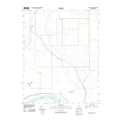
2010 Map of Bayouville
USGS Topo · Published 2010About this map
The Mississippi River forms the southern boundary of this Mississippi County survey, defining a landscape shaped by intricate drainage systems and agricultural life. The massive Birds Point New Madrid Levee stands as a primary engineering feature, shielding the low-lying terrain from the river's seasonal shifts. Inland, the community of Pinhook and the small settlement at Bayouville anchor a grid of rural roads and drainage canals like the Spillway Ditch and Saint Johns Diversion Ditch, which converted former wetlands into productive fields. Genealogists and local historians can find family-named landmarks such as the Barker Cemetery and Sugar Tree Ridge Cemetery near the elevated ground of Sugar Tree Ridge. The presence of Three States Landing and Dry Bayou Landing along the riverbank points to a history of waterborne transport and commerce in this corner of Missouri, while natural features like Sixmile Ponds and James Bayou remain as remnants of the area's original hydrological character.
Find a feature on this map
33 named features on this map. Tap any name to fly to it.
Don’t see what you’re looking for? This feature index may not catch every label — zoom into the map to look around manually.
Map Details
Editions of this 2010 Bayouville Map
This is the sole edition of this map. No revisions or reprints were ever made.
Other maps of this area

1939 · Wickliffe
USGS Topo · 1:62,500

1939 · Charleston
USGS Topo · 1:62,500

1939 · Hickman
USGS Topo · 1:62,500

1939 · Bayouville
USGS Topo · 1:62,500

1951 · Bondurant
USGS Topo · 1:24,000

1951 · Hickman
USGS Topo · 1:24,000

1951 · Wolf Island
USGS Topo · 1:24,000

1951 · Wickliffe SW
USGS Topo · 1:24,000

1951 · Hubbard Lake
USGS Topo · 1:24,000

1952 · Wickliffe
USGS Topo · 1:62,500