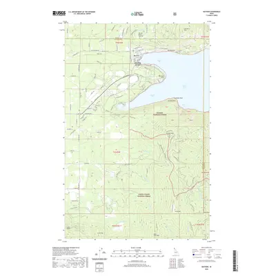
2020 Map of Bayview
USGS Topo · Published 2020About this map
Bayview sits prominently along the western shores of Lake Pend Oreille, where the deep waters of Scenic Bay meet a landscape of steep timberlands and public preserves. This survey illustrates a complex boundary between the Kaniksu National Forest and the Coeur d'Alene National Forest, marked by significant elevations like Bernard Peak and Chilco Mtn. The shoreline is characterized by distinctive geological features such as Blackwell Point, Steamboat Rock, and Bernard Point, which delineate the small inlets of Idlewilde Bay and Echo Bay.
Find a feature on this map
93 named features on this map. Tap any name to fly to it.
Don’t see what you’re looking for? This feature index may not catch every label — zoom into the map to look around manually.
Map Details
Editions of this 2020 Bayview Map
This is the sole edition of this map. No revisions or reprints were ever made.
Other maps of this area

1901 · Sandpoint
USGS Topo · 1:125,000

1903 · Rathdrum
USGS Topo · 1:125,000

1909 · Cataldo
USGS Topo · 1:125,000

1911 · Cataldo
USGS Topo · 1:125,000

1911 · Priest Lake
USGS Topo · 1:250,000

1911 · Sandpoint
USGS Topo · 1:125,000

1913 · Priest Lake
USGS Topo · 1:250,000

1949 · Packsaddle Mtn
USGS Topo · 1:62,500

1951 · Packsaddle Mtn
USGS Topo · 1:62,500

1955 · Spokane
USGS Topo · 1:250,000