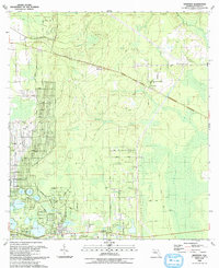
1993 Map of Baywood
USGS Topo · Published 1993About this map
Etonia and the Palmetto Branch drain a landscape defined by its numerous lakes and subtle drainage basins in this northern Florida region during the early 1990s. The settlement of Carraway serves as a local hub near the Macedonia Missionary Ch, while the southern reaches of the map show the established communities of Hollister and Mannville. A notable historic infrastructure feature is the Old RR Grade cutting through the center of the sheet, tracing a former transportation corridor that once linked these small rural outposts.
Find a feature on this map
67 named features on this map. Tap any name to fly to it.
Don’t see what you’re looking for? This feature index may not catch every label — zoom into the map to look around manually.
Map Details
Editions of this 1993 Baywood Map
This is the sole edition of this map. No revisions or reprints were ever made.
Other maps of this area

1912 · Palatka
USGS Topo · 1:48,000

1915 · Palatka
USGS Topo · 1:62,500

1915 · Interlachen
USGS Topo · 1:48,000

1916 · Interlachen
USGS Topo · 1:62,500

1942 · Ates Creek
USGS Topo · 1:62,500

1944 · Interlachen
USGS Topo · 1:62,500

1947 · Bostwick
USGS Topo · 1:50,000

1949 · Rice Creek
USGS Topo · 1:24,000

1949 · Bostwick
USGS Topo · 1:24,000

1949 · Keuka
USGS Topo · 1:24,000