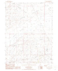
1986 Map of Bean Flat East
USGS Topo · Published 1986About this map
The Old Pony Express Trail cuts across the northwest corner of this Nevada landscape, providing a tangible link to the historic mail route that once spanned the West. Situated in the high desert of Eureka County, the terrain is defined by the broad expanses of Kobeh Valley, Grubb Flat, and Bean Flat. This environment is characterized by its vital water sources, including a concentration of named springs in the southeast such as Warm Spring, Cold Spring, and Twin Springs. Settlement activity is sparse, marked primarily by a Corral and Shamrock Spring, while a Wooden Pole Trans Line tracks across the central portion of the map. The drainage patterns of Willow Creek Wash illustrate the intermittent water flow common to this arid region during the mid-1980s.
Find a feature on this map
16 named features on this map. Tap any name to fly to it.
Don’t see what you’re looking for? This feature index may not catch every label — zoom into the map to look around manually.
Map Details
Editions of this 1986 Bean Flat East Map
This is the sole edition of this map. No revisions or reprints were ever made.
Other maps of this area

1926 · Roberts Mountains
USGS Topo · 1:250,000

1929 · Roberts Mountains
USGS Topo · 1:250,000

1955 · Millett
USGS Topo · 1:250,000

1956 · Bartine Ranch
USGS Topo · 1:62,500

1956 · Antelope Peak
USGS Topo · 1:62,500

1956 · Ackerman Canyon
USGS Topo · 1:62,500

1959 · Millett
USGS Topo · 1:250,000

1960 · Hickison Summit
USGS Topo · 1:62,500

1978 · Summit Mountain
USGS Topo · 1:100,000

1979 · Simpson Park Mtns
USGS Topo · 1:100,000