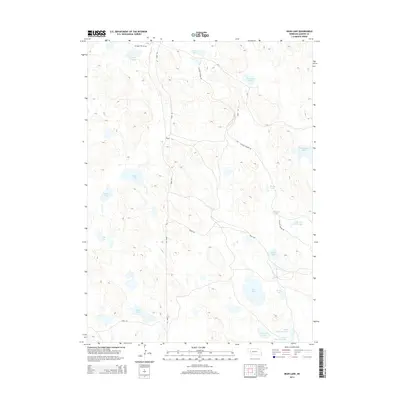
2014 Map of Bean Lake
USGS Topo · Published 2014About this map
Meyer Lakes and Trainor Lake sit at the northern edge of this Sandhills landscape, where a dense network of depressional basins forms a complex hydrologic system in Garden County. The terrain is defined by its numerous named water bodies, ranging from the large Alkali Lake and Wilson Lake in the west to the smaller Smith Lake and Perrin Lake to the south. Transport through this wetland-heavy region is maintained by a grid of rural routes including Road 155 and Road 108, while Alliance Refuge Rd cuts diagonally across the northern and eastern sections. Notable family-named landmarks like Old Ladys Lake, Ramelli Slough, and Charleys Lake reflect the local history of land use and settlement in this portion of Nebraska. The proximity of Upper Tree Claim Lake suggest historical efforts at establishing timber in this treeless prairie environment.
Find a feature on this map
22 named features on this map. Tap any name to fly to it.
Don’t see what you’re looking for? This feature index may not catch every label — zoom into the map to look around manually.
Map Details
Editions of this 2014 Bean Lake Map
This is the sole edition of this map. No revisions or reprints were ever made.
Other maps of this area

1896 · Browns Creek
USGS Topo · 1:125,000

1899 · Browns Creek
USGS Topo · 1:125,000

1949 · Mumper
USGS Topo · 1:62,500

1950 · Crescent Lake
USGS Topo · 1:62,500

1950 · Storm Lake
USGS Topo · 1:62,500

1954 · Scottsbluff
USGS Topo · 1:250,000

1958 · Scottsbluff
USGS Topo · 1:250,000

1971 · Richardson Lake
USGS Topo · 1:24,000
1971 · Tar Valley
USGS Topo · 1:24,000

1985 · Crescent Lake
USGS Topo · 1:100,000