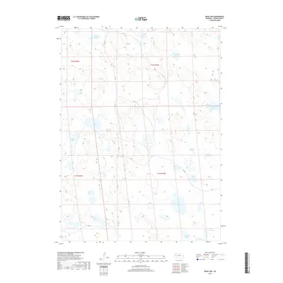
2017 Map of Bean Lake
USGS Topo · Published 2017About this map
Meyer Lakes and Trainor Lake sit at the northern edge of this high plains landscape, part of a dense cluster of natural depressions and wetlands in Garden County. The terrain is defined by its hydrology, featuring a series of named basins such as Alkali Lake, Wilson Lake, and the uniquely named Old Ladys Lake. This 2017 survey reflects the enduring cattle-country character of the Nebraska Sandhills, where a sparse network of county roads like RD 114 and RD 155 connects remote ranching sections. The presence of Ramelli Slough and Upper Tree Claim Lake points to the area's history of land claims and water management in an environment where moisture is the most valuable resource. Further south, the map details more localized water bodies including Smith Lake, Bean Lake, and Perrin Lake.
Find a feature on this map
26 named features on this map. Tap any name to fly to it.
Don’t see what you’re looking for? This feature index may not catch every label — zoom into the map to look around manually.
Map Details
Editions of this 2017 Bean Lake Map
This is the sole edition of this map. No revisions or reprints were ever made.
Other maps of this area

1896 · Browns Creek
USGS Topo · 1:125,000

1899 · Browns Creek
USGS Topo · 1:125,000

1949 · Mumper
USGS Topo · 1:62,500

1950 · Crescent Lake
USGS Topo · 1:62,500

1950 · Storm Lake
USGS Topo · 1:62,500

1954 · Scottsbluff
USGS Topo · 1:250,000

1958 · Scottsbluff
USGS Topo · 1:250,000

1971 · Richardson Lake
USGS Topo · 1:24,000
1971 · Tar Valley
USGS Topo · 1:24,000

1985 · Crescent Lake
USGS Topo · 1:100,000