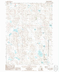
1986 Map of Bean Lake
USGS Topo · Published 1986About this map
Crescent Lake National Wildlife Refuge dominates the eastern landscape of this Garden County region, protecting a complex system of Nebraska Sandhills wetlands. The area is defined by its numerous shallow lakes and sloughs, such as Romelli Slough, which weave through the dune formations. Remote ranching operations like the Eldred Ranch represent the primary human imprint on this otherwise wild terrain. The map illustrates a delicate hydrological network where water bodies like Alkali Lake, Wilson Lake, and Bean Lake provide critical habitat and reference points in a sea of shifting grass and sand. Many of the lakes carry family names or descriptive titles, such as Old Ladys Lake and Trainor Lake, suggesting a long history of local habitation and land use centered around these permanent water sources.
Find a feature on this map
23 named features on this map. Tap any name to fly to it.
Don’t see what you’re looking for? This feature index may not catch every label — zoom into the map to look around manually.
Map Details
Editions of this 1986 Bean Lake Map
This is the sole edition of this map. No revisions or reprints were ever made.
Other maps of this area

1896 · Browns Creek
USGS Topo · 1:125,000

1899 · Browns Creek
USGS Topo · 1:125,000

1949 · Mumper
USGS Topo · 1:62,500

1950 · Crescent Lake
USGS Topo · 1:62,500

1950 · Storm Lake
USGS Topo · 1:62,500

1954 · Scottsbluff
USGS Topo · 1:250,000

1958 · Scottsbluff
USGS Topo · 1:250,000

1971 · Richardson Lake
USGS Topo · 1:24,000
1971 · Tar Valley
USGS Topo · 1:24,000

1985 · Crescent Lake
USGS Topo · 1:100,000