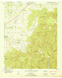
1951 Map of Beans Creek
USGS Topo · Published 1951About this map
Belvidere and its rural surroundings in Franklin County are defined by a sharp contrast between fertile valley floor and the steep escarpments of Buncombe Ridge. The northern plains are heavily marked by early agricultural settlement, serviced by the Nashville Chattanooga and St Louis railroad which cuts diagonally through Maxwell and Old Salem. This map reveals a community-centric landscape with numerous local schools and houses of worship, such as Hatchett Sch and Belvidere Ch, indicating a densely settled farming population before the mid-century.
Find a feature on this map
80 named features on this map. Tap any name to fly to it.
Don’t see what you’re looking for? This feature index may not catch every label — zoom into the map to look around manually.
Map Details
Editions of this 1951 Beans Creek Map
This is the sole edition of this map. No revisions or reprints were ever made.
Other maps of this area

1888 · Scottsboro
USGS Topo · 1:125,000

1892 · Scottsboro
USGS Topo · 1:125,000

1928 · Decherd
USGS Topo · 1:62,500

1936 · King Cove
USGS Topo · 1:24,000

1936 · Beans Creek
USGS Topo · 1:24,000

1936 · Hytop
USGS Topo · 1:24,000

1936 · Winchester
USGS Topo · 1:24,000

1936 · Huntland
USGS Topo · 1:24,000

1936 · Belvidere
USGS Topo · 1:24,000

1936 · Pitcher Ridge
USGS Topo · 1:24,000