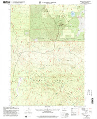
1999 Map of Bear Butte
USGS Topo · Published 2002About this map
Fremont National Forest and Winema National Forest converge in this high-desert volcanic landscape, where the geography is defined by a series of prominent peaks and meadows. The area around Bear Butte and Doeskin Butte reveals a rugged drainage system where Doeskin Creek and Buckskin Creek carve through the timbered terrain. Historically, the presence of the Porter Ranch and landmarks like Emery Well suggest a history of high-country grazing and seasonal habitation near Bear Flat. The map also documents the industrial footprint of the region through several Cinder Pit locations and a Quarry, reflecting the geologic utility of the volcanic cinder cones and buttes found here, from Fire Butte to Doe Butte.
Find a feature on this map
26 named features on this map. Tap any name to fly to it.
Don’t see what you’re looking for? This feature index may not catch every label — zoom into the map to look around manually.
Map Details
Editions of this 1999 Bear Butte Map
This is the sole edition of this map. No revisions or reprints were ever made.
Other maps of this area

1889 · Klamath
USGS Topo · 1:250,000

1894 · Klamath
USGS Topo · 1:250,000

1935 · Chemult
USGS Topo · 1:96,000

1941 · Chemult
USGS Topo · 1:125,000

1955 · Crescent
USGS Topo · 1:250,000

1955 · Klamath Falls
USGS Topo · 1:250,000

1957 · Crescent
USGS Topo · 1:250,000

1957 · Klamath Marsh
USGS Topo · 1:62,500

1958 · Crescent
USGS Topo · 1:250,000

1958 · Klamath Falls
USGS Topo · 1:250,000