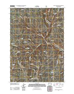
2011 Map of Bear Canyon Butte
USGS Topo · Published 2011About this map
Bear Canyon Butte and Emigrant Butte command this high desert landscape in Harney County, where a network of seasonal water sources and primitive forest roads defines the human presence. This 2011 survey illustrates the reliance on localized water points such as Little Emigrant Spring, Lost Guard Spring, and Beaver Rock Spring, many of which are linked by historic routes like Coyote Spring Rd and Dipping Vat Spring Rd. Public land management is evident through the inclusion of Rainbow Campground and the Corbett Cabin, while the presence of the Buck Spring Reservoir highlights the modification of the natural drainage to support range use. The map reveals the intricate dissection of the plateau by Bear Canyon Creek and Little Emigrant Creek, showing a terrain largely shaped by its hydrological patterns.
Find a feature on this map
39 named features on this map. Tap any name to fly to it.
Don’t see what you’re looking for? This feature index may not catch every label — zoom into the map to look around manually.
Map Details
Editions of this 2011 Bear Canyon Butte Map
This is the sole edition of this map. No revisions or reprints were ever made.
Other maps of this area

1955 · Burns
USGS Topo · 1:250,000

1958 · Burns
USGS Topo · 1:250,000

1959 · Burns
USGS Topo · 1:250,000

1959 · Sawtooth Creek
USGS Topo · 1:62,500

1961 · Delintment Lake
USGS Topo · 1:62,500
1981 · Egypt Canyon
USGS Topo · 1:24,000
1981 · Holmes Canyon
USGS Topo · 1:24,000
1982 · Dry Mountain
USGS Topo · 1:24,000
1990 · Big Mowich Mountain
USGS Topo · 1:24,000
1990 · Bear Canyon Butte
USGS Topo · 1:24,000