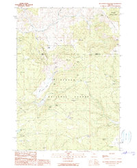
1990 Map of Big Mowich Mountain
USGS Topo · Published 1990About this map
Och Oco National Forest and Malheur National Forest meet along a county boundary in this high-elevation landscape. The terrain is defined by a series of north-south drainages, including Beaver Creek and Freeman Creek, separated by prominent elevations like Big Mowich Mtn and Little Mowich Mtn. Human presence is largely tied to agricultural outposts and forest management, evidenced by several family-named locations such as Harris Ranch, J M Ranch, and Allison Ranch. The importance of water management in this environment is underscored by the dense network of named springs, ranging from the uniquely named Stinking Spring to the functional Upper Crowfoot Spring and Button Flat Spring. The Allison Guard Sta serves as a central landmark for administrative oversight in the southern portion of the sheet, while topographical features like Dobson Ridge and Silver Howard Valley provide a clear view of the natural corridors used for movement through the timbered hills.
Find a feature on this map
58 named features on this map. Tap any name to fly to it.
Don’t see what you’re looking for? This feature index may not catch every label — zoom into the map to look around manually.
Map Details
Editions of this 1990 Big Mowich Mountain Map
This is the sole edition of this map. No revisions or reprints were ever made.
Other maps of this area

1932 · Dayville
USGS Topo · 1:125,000

1936 · Dayville
USGS Topo · 1:125,000

1955 · Burns
USGS Topo · 1:250,000

1955 · Canyon City
USGS Topo · 1:250,000

1958 · Burns
USGS Topo · 1:250,000

1959 · Burns
USGS Topo · 1:250,000

1959 · Canyon City
USGS Topo · 1:250,000

1959 · Sawtooth Creek
USGS Topo · 1:62,500

1961 · Delintment Lake
USGS Topo · 1:62,500

1961 · Izee
USGS Topo · 1:62,500