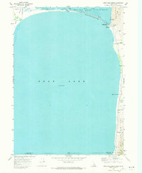
1970 Map of Bear Lake North
USGS Topo · Published 1973About this map
The state line between Idaho and Utah bisects the blue expanse of Bear Lake, where the northern shoreline is defined by recreation and conservation areas. Along the northern edge, North Beach State Park stretches beside the Mud Lake National Wildlife Refuge, indicating a landscape managed for both public access and habitat protection. A notable Pumping Station near the small settlement of Lifton marks the infrastructure required to manage the flow between Mud Lake and the larger body of water.
Find a feature on this map
22 named features on this map. Tap any name to fly to it.
Don’t see what you’re looking for? This feature index may not catch every label — zoom into the map to look around manually.
Map Details
Editions of this 1970 Bear Lake North Map
This is the sole edition of this map. No revisions or reprints were ever made.
Other maps of this area

1909 · Montpelier
USGS Topo · 1:125,000

1911 · Montpelier
USGS Topo · 1:125,000

1912 · Randolph
USGS Topo · 1:125,000

1954 · Ogden
USGS Topo · 1:250,000

1955 · Preston
USGS Topo · 1:250,000

1958 · Ogden
USGS Topo · 1:250,000

1958 · Preston
USGS Topo · 1:250,000

1960 · Ogden
USGS Topo · 1:250,000

1962 · Preston
USGS Topo · 1:250,000

1967 · Paris
USGS Topo · 1:24,000