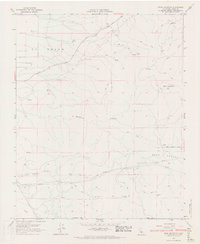
1966 Map of Bear Mountain
USGS Topo · Published 1967About this map
El Tejon ranch lands define this portion of the Tehachapi Mountains in the mid-1960s, a landscape marked by steep drainages and high plateaus. The topography is dominated by the massive bulk of Bear Mountain and the descent into Sycamore Canyon and Little Sycamore Canyon. Evidence of mid-century infrastructure is clear through the network of Pipelines cutting across the southern sections near Bear Valley, alongside a primitive network of Jeep Trails and ranch roads like Bear Valley Road. Small, remote outposts such as Mart and Oak Flat appear as quiet landmarks in a terrain characterized by sparse water sources like Rock Spring and Clear Creek. The inclusion of specific local markers like Black Oak and Horsethief Flat provides a localized record of the interior mountain ranching culture before more modern development reached these higher elevations.
Find a feature on this map
57 named features on this map. Tap any name to fly to it.
Don’t see what you’re looking for? This feature index may not catch every label — zoom into the map to look around manually.
Map Details
Editions of this 1966 Bear Mountain Map
3 editions found
Other maps of this area

1914 · Caliente
USGS Topo · 1:125,000

1929 · Bena
USGS Topo · 1:31,680

1930 · Bear Mountain
USGS Topo · 1:31,680

1930 · Arvin
USGS Topo · 1:31,680

1931 · Edison
USGS Topo · 1:31,680

1931 · Tejon Hills
USGS Topo · 1:31,680

1932 · Bena
USGS Topo · 1:31,680

1933 · Arvin
USGS Topo · 1:31,680

1933 · Tejon Hills
USGS Topo · 1:31,680

1933 · Bear Mountain
USGS Topo · 1:31,680