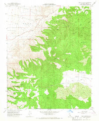
1966 Map of Bear Mountain
USGS Topo · Published 1967About this map
Bear Mountain dominates this portion of the Tehachapi range during the mid-1960s, overlooking the transition from the steep canyons of El Tejon to the high basin of Bear Valley. The landscape is defined by its water management and infrastructure, evidenced by numerous Water Tanks and a system of Pipelines traversing the slopes. Small mountain flats like Horsethief Flat and Oak Flat serve as landmarks amidst a network of Jeep Trails and larger arteries like Bear Mtn Blvd. The terrain is deeply incised by drainages such as Sycamore Canyon and Little Sycamore Canyon, while seasonal water sources like Rock Spring and Clear Creek provide vital points of interest in this arid high-elevation environment. This survey captures the area just before significant modern development, documenting the ranching and utility corridors of the era.
Find a feature on this map
19 named features on this map. Tap any name to fly to it.
Don’t see what you’re looking for? This feature index may not catch every label — zoom into the map to look around manually.
Map Details
Editions of this 1966 Bear Mountain Map
3 editions found
Other maps of this area

1914 · Caliente
USGS Topo · 1:125,000

1929 · Bena
USGS Topo · 1:31,680

1930 · Bear Mountain
USGS Topo · 1:31,680

1930 · Arvin
USGS Topo · 1:31,680

1931 · Edison
USGS Topo · 1:31,680

1931 · Tejon Hills
USGS Topo · 1:31,680

1932 · Bena
USGS Topo · 1:31,680

1933 · Arvin
USGS Topo · 1:31,680

1933 · Tejon Hills
USGS Topo · 1:31,680

1933 · Bear Mountain
USGS Topo · 1:31,680