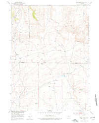
1951 Map of Bear Spring
USGS Topo · Published 1977About this map
Demorst Ranch sits at the heart of this high-elevation landscape, where the seasonal management of water dictated the patterns of ranching life. Located along the border of Natrona and Carbon Counties, the area is defined by its complex network of water sources, from the isolated Horse Spring and McCune Springs to the vital Anda Reservoir. These points were essential anchors for livestock in a region dominated by drainage systems like Cottonwood Creek and the meandering Bear Spring Creek. To the south, Josendal Springs marks another waypoint for those traveling this country. The primary thoroughfare, Kortes Road, provides the only major access through the winding Canyon topography, linking the high plateaus and remote ranching operations during this mid-century period of development in the Missouri River Basin.
Find a feature on this map
20 named features on this map. Tap any name to fly to it.
Don’t see what you’re looking for? This feature index may not catch every label — zoom into the map to look around manually.
Map Details
Editions of this 1951 Bear Spring Map
3 editions found
Other maps of this area

1950 · Alcova SE
USGS Topo · 1:24,000

1950 · Alcova
USGS Topo · 1:24,000

1951 · Benton Basin
USGS Topo · 1:24,000

1951 · Bear Mountain
USGS Topo · 1:24,000

1951 · Bear Spring
USGS Topo · 1:24,000

1951 · Pathfinder Dam
USGS Topo · 1:24,000

1953 · Leo
USGS Topo · 1:24,000

1953 · Fourmile Point
USGS Topo · 1:24,000

1953 · Fourmile Ridge
USGS Topo · 1:24,000

1955 · Casper
USGS Topo · 1:250,000