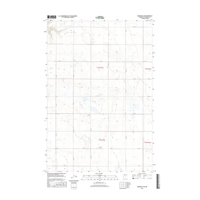
2016 Map of Beardsley NE
USGS Topo · Published 2016About this map
Glacial wetland pockets and a rigid grid of rural roads characterize this portion of Traverse County, where the landscape is still defined by the Public Land Survey System divisions of t126n r47w and t125n r47w. The agricultural terrain is punctuated by small, isolated basins and prairie potholes, typical of this region's post-glacial topography. Human presence is anchored by local landmarks such as Zion Cem and Siloah Cem, which serve as primary points of interest for genealogists and local historians tracing the settlement patterns of this farming community. The movement of goods and people relies on a network of county routes, including the prominent north-south corridor of Co Hwy 5 and the east-west passage of Co Hwy 4, which cross the open prairie to link the scattered farmsteads and rural sections.
Find a feature on this map
25 named features on this map. Tap any name to fly to it.
Don’t see what you’re looking for? This feature index may not catch every label — zoom into the map to look around manually.
Map Details
Editions of this 2016 Beardsley NE Map
This is the sole edition of this map. No revisions or reprints were ever made.
Other maps of this area

1915 · White Rock
USGS Topo · 1:62,500

1916 · Beardsley
USGS Topo · 1:62,500

1918 · White Rock
USGS Topo · 1:62,500

1918 · Beardsley
USGS Topo · 1:62,500

1950 · Graceville
USGS Topo · 1:62,500

1951 · Wheaton
USGS Topo · 1:62,500

1953 · Milbank
USGS Topo · 1:250,000

1958 · Milbank
USGS Topo · 1:250,000
1972 · Rosholt
USGS Topo · 1:24,000
1972 · Wheaton West
USGS Topo · 1:24,000