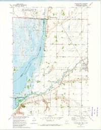
1972 Map of Wheaton West
USGS Topo · Published 1974About this map
The Chicago Milwaukee St Paul and Pacific railroad bisects this landscape, connecting the agricultural hub of Wheaton to the wider region during the early 1970s. The map illustrates a complex water management system along the border of Minnesota and South Dakota, where the Bois De Sioux River flows north from White Rock Dam. Large areas of controlled inundation are evident at Mud Lake within the Sisseton Indian Reservation and further south at Lake Traverse, reflecting the engineering of the regional watershed. Local landmarks such as the Nelson Cem and Larsens Camp provide specific points of interest for genealogists and local historians. The survey also captures the municipal infrastructure of the era, including the Wheaton Municipal Airport and the network of gravel pits that supported local development and road building near the Mustinka River.
Find a feature on this map
31 named features on this map. Tap any name to fly to it.
Don’t see what you’re looking for? This feature index may not catch every label — zoom into the map to look around manually.
Map Details
Editions of this 1972 Wheaton West Map
This is the sole edition of this map. No revisions or reprints were ever made.
Other maps of this area

1915 · White Rock
USGS Topo · 1:62,500

1916 · Beardsley
USGS Topo · 1:62,500

1918 · White Rock
USGS Topo · 1:62,500

1918 · Beardsley
USGS Topo · 1:62,500

1950 · Graceville
USGS Topo · 1:62,500

1951 · Wheaton
USGS Topo · 1:62,500

1953 · Milbank
USGS Topo · 1:250,000

1958 · Milbank
USGS Topo · 1:250,000
1972 · La Mars
USGS Topo · 1:24,000
1972 · Rosholt
USGS Topo · 1:24,000