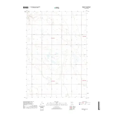
2019 Map of Beardsley NE
USGS Topo · Published 2019About this map
Siloah Cem and Zion Cem sit within the expansive agricultural grid of Traverse County, where the landscape is defined by the intersection of townships t125n r47w and t126n r47w. This prairie region, captured in late-2010s data, shows a highly organized network of county roads such as Co Hwy 4 and Co Hwy 6 that segment the land into productive sections. The map reveals the persistence of rural landmarks and small family cemeteries that have anchored this farming community for generations. Scattered wetlands and drainage patterns weave through the rectilinear road system of 570th St and 650th Ave, reflecting the natural hydrology of the Minnesota prairie alongside modern infrastructure.
Find a feature on this map
25 named features on this map. Tap any name to fly to it.
Don’t see what you’re looking for? This feature index may not catch every label — zoom into the map to look around manually.
Map Details
Editions of this 2019 Beardsley NE Map
This is the sole edition of this map. No revisions or reprints were ever made.
Other maps of this area

1915 · White Rock
USGS Topo · 1:62,500

1916 · Beardsley
USGS Topo · 1:62,500

1918 · White Rock
USGS Topo · 1:62,500

1918 · Beardsley
USGS Topo · 1:62,500

1950 · Graceville
USGS Topo · 1:62,500

1951 · Wheaton
USGS Topo · 1:62,500

1953 · Milbank
USGS Topo · 1:250,000

1958 · Milbank
USGS Topo · 1:250,000
1972 · Rosholt
USGS Topo · 1:24,000
1972 · Wheaton West
USGS Topo · 1:24,000