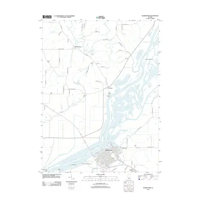
2012 Map of Beardstown
USGS Topo · Published 2012About this map
The Illinois River dominates this landscape, weaving through a complex network of backwaters and islands including Grape Island and Sugar Creek Island. On its eastern banks, Beardstown stands as a significant riverfront hub, while the smaller settlements of Frederick and Oak Grove sit at the transition from the river bottomlands to the higher bluffs. The map reveals an intricate hydrological system where the Sangamon River meets the Illinois, creating expansive features like Muscooten Bay and Wood Slough. Family-named cemeteries such as Messerer Cem, Marchant Cem, and Bellomy Cem are scattered across the northern uplands near Pleasant View, providing valuable data points for those tracing local lineages. Transportation routes like Old Route 67 and proximity to Briggs Landing highlight the area's historical reliance on both river commerce and road connectivity.
Find a feature on this map
87 named features on this map. Tap any name to fly to it.
Don’t see what you’re looking for? This feature index may not catch every label — zoom into the map to look around manually.
Map Details
Editions of this 2012 Beardstown Map
This is the sole edition of this map. No revisions or reprints were ever made.
Other maps of this area

1923 · Rushville
USGS Topo · 1:62,500

1926 · Beardstown
USGS Topo · 1:62,500

1926 · Rushville
USGS Topo · 1:62,500

1928 · Meredosia
USGS Topo · 1:62,500

1929 · Arenzville
USGS Topo · 1:62,500

1931 · Meredosia
USGS Topo · 1:62,500

1932 · Arenzville
USGS Topo · 1:62,500

1944 · Beardstown
USGS Topo · 1:62,500

1948 · Quincy
USGS Topo · 1:250,000

1956 · Quincy
USGS Topo · 1:250,000