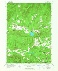
1945 Map of Bearsville
USGS Topo · Published 1968About this map
Woodstock and the surrounding Catskill highlands appear here in a transition period following World War II, based on 1943 aerial photography and 1945 field checks. The settlement pattern shows a concentration of small hamlets such as Bearsville and Byrdcliffe linked by the winding corridor of the Saw Kill. The central prominence of Cooper Lake serves as a major hydrologic landmark, while the mountainous terrain is defined by peaks like Mt Tobias and Guardian Mountain.
Find a feature on this map
52 named features on this map. Tap any name to fly to it.
Don’t see what you’re looking for? This feature index may not catch every label — zoom into the map to look around manually.
Map Details
Editions of this 1945 Bearsville Map
Other maps of this area

1892 · Kaaterskill
USGS Topo · 1:62,500

1893 · Kaaterskill
USGS Topo · 1:62,500

1894 · Kaaterskill
USGS Topo · 1:62,500

1899 · Kaaterskill
USGS Topo · 1:62,500

1900 · Phoenicia
USGS Topo · 1:62,500

1901 · Rosendale
USGS Topo · 1:62,500

1903 · Rosendale
USGS Topo · 1:62,500

1903 · Phoenicia
USGS Topo · 1:62,500

1903 · Kaaterskill
USGS Topo · 1:62,500

1903 · Slide Mountain
USGS Topo · 1:62,500