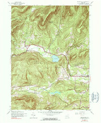
1945 Map of Bearsville
USGS Topo · Published 1990About this map
Woodstock and the surrounding hamlets of the Catskill Park are documented here during the mid-1940s, a period when the area maintained its rural character and early artistic community roots. The settlement pattern follows the narrow valleys carved by the Beaver Kill and Saw Kill, with clusters of activity at Bearsville, Lake Hill, and Shady. The presence of several numbered schoolhouses, such as School No 5 and School No 1, highlights the decentralized educational system of the era before widespread consolidation.
Find a feature on this map
44 named features on this map. Tap any name to fly to it.
Don’t see what you’re looking for? This feature index may not catch every label — zoom into the map to look around manually.
Map Details
Editions of this 1945 Bearsville Map
Other maps of this area

1892 · Kaaterskill
USGS Topo · 1:62,500

1893 · Kaaterskill
USGS Topo · 1:62,500

1894 · Kaaterskill
USGS Topo · 1:62,500

1899 · Kaaterskill
USGS Topo · 1:62,500

1900 · Phoenicia
USGS Topo · 1:62,500

1901 · Rosendale
USGS Topo · 1:62,500

1903 · Rosendale
USGS Topo · 1:62,500

1903 · Phoenicia
USGS Topo · 1:62,500

1903 · Kaaterskill
USGS Topo · 1:62,500

1903 · Slide Mountain
USGS Topo · 1:62,500