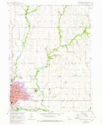
1957 Map of Beatrice East
USGS Topo · Published 1980About this map
The Big Blue River sweeps through the southern portion of this landscape, anchoring the city of Beatrice as it transitioned from a mid-century rail hub into a regional center. The urban footprint, expanded by 1978 revisions shown in purple, reveals the growth of residential and industrial areas near the Union Pacific and Chicago Rock Island and Pacific railroad lines. On the eastern edge of the city, the extensive grounds of the Beatrice State Home and Evergreen Home Cemetery create a distinct institutional corridor.
Find a feature on this map
38 named features on this map. Tap any name to fly to it.
Don’t see what you’re looking for? This feature index may not catch every label — zoom into the map to look around manually.
Map Details
Editions of this 1957 Beatrice East Map
2 editions found
Other maps of this area

1955 · Lincoln
USGS Topo · 1:250,000

1957 · Lincoln
USGS Topo · 1:250,000

1957 · Clatonia
USGS Topo · 1:24,000

1957 · Beatrice West
USGS Topo · 1:24,000

1957 · Beatrice East
USGS Topo · 1:24,000

1958 · Lincoln
USGS Topo · 1:250,000

1964 · Pickrell
USGS Topo · 1:24,000

1964 · Blue Springs
USGS Topo · 1:24,000

1965 · Adams
USGS Topo · 1:24,000

1970 · Diller NE
USGS Topo · 1:24,000