
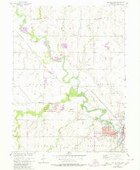
1957 Map of Beatrice West
USGS Topo · Published 1958About this map
Homestead National Monument of America anchors this 1957 survey, preserving the site of one of the first claims under the Homestead Act. The landscape is defined by the winding course of the Big Blue River, which is paralleled by the Chicago Burlington and Quincy railroad as it approaches the city of Beatrice. The map captures a high density of rural institutions, including numerous schoolhouses such as Caldwell Sch, Dolen Sch, and Cedar Sch, alongside the Mennonite Ch. This density of named schools and the presence of the County Fairground and Beatrice Municipal Airport reflect a well-established agricultural community at its mid-century peak. Small settlements like Hoag and Glenover serve as rail-side nodes, while the township boundaries of Blakely, Midland, and Lincoln provide a clear genealogical framework for researchers tracing family lands in Gage County.
Find a feature on this map
43 named features on this map. Tap any name to fly to it.
Don’t see what you’re looking for? This feature index may not catch every label — zoom into the map to look around manually.
Map Details
Editions of this 1957 Beatrice West Map
2 editions found
Other maps of this area

1955 · Lincoln
USGS Topo · 1:250,000

1957 · Lincoln
USGS Topo · 1:250,000

1957 · Plymouth
USGS Topo · 1:24,000

1957 · Clatonia
USGS Topo · 1:24,000

1957 · Wilber
USGS Topo · 1:24,000

1957 · Beatrice East
USGS Topo · 1:24,000

1958 · Lincoln
USGS Topo · 1:250,000

1964 · Pickrell
USGS Topo · 1:24,000

1964 · Blue Springs
USGS Topo · 1:24,000

1970 · Diller NE
USGS Topo · 1:24,000