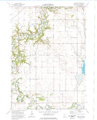
1974 Map of Beauford
USGS Topo · Published 1976About this map
The Le Sueur River and Cobb River carve deep, winding paths through this section of Blue Earth County, defining a landscape of sharp river bluffs and fertile plains. Centered on the settlement of Beauford, the area shows a distinct transition from the natural watercourses of the western half to the highly engineered drainage systems of the east. This shift is marked by the presence of County Ditch No 88 and County Ditch No 25, which channel water toward Rice Lake. The rural character of the mid-1970s is preserved through features such as the Decoria Cem, Redeemer Ch, and a local Townhall. Land use is further characterized by scattered Gravel Pits, a Golf Course near the river bends, and an unpaved Landing Strip, reflecting a community integrated with the terrain of Hungry Hollow.
Find a feature on this map
27 named features on this map. Tap any name to fly to it.
Don’t see what you’re looking for? This feature index may not catch every label — zoom into the map to look around manually.
Map Details
Editions of this 1974 Beauford Map
This is the sole edition of this map. No revisions or reprints were ever made.
Other maps of this area

1950 · Mankato East
USGS Topo · 1:62,500

1951 · Mankato East
USGS Topo · 1:62,500

1951 · Mankato West
USGS Topo · 1:62,500

1953 · Saint Paul
USGS Topo · 1:250,000

1953 · New Ulm
USGS Topo · 1:250,000

1954 · Fairmont
USGS Topo · 1:250,000

1954 · Mason City
USGS Topo · 1:250,000

1957 · New Ulm
USGS Topo · 1:250,000

1957 · Mason City
USGS Topo · 1:250,000

1958 · New Ulm
USGS Topo · 1:250,000