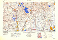
1984 Map of Beaumont
USGS Topo · Published 1984About this map
Beaumont and the surrounding Piney Woods region are shown here in the mid-1980s, revealing a landscape defined by industrial forestry and massive water management projects. The massive Lake Livingston and Lake Conroe dominate the western half, while the Trinity River and Neches River systems carve through the dense timberlands. Large institutional footprints are visible in the northwest, including the Eastham State Prison Farm and Ferguson State Prison Farm.
Find a feature on this map
61 named features on this map. Tap any name to fly to it.
Don’t see what you’re looking for? This feature index may not catch every label — zoom into the map to look around manually.
Map Details
Editions of this 1984 Beaumont Map
3 editions found

Other maps of this area

1914 · Navasota
USGS Topo · 1:62,500

1915 · Cypress
USGS Topo · 1:24,000

1916 · Rose Hill
USGS Topo · 1:24,000

1916 · Aldine
USGS Topo · 1:24,000

1916 · Crosby
USGS Topo · 1:24,000

1916 · Louetta
USGS Topo · 1:24,000

1916 · Harmaston
USGS Topo · 1:24,000

1916 · Moonshine Hill
USGS Topo · 1:24,000

1916 · Hockley
USGS Topo · 1:24,000

1916 · Satsuma
USGS Topo · 1:24,000