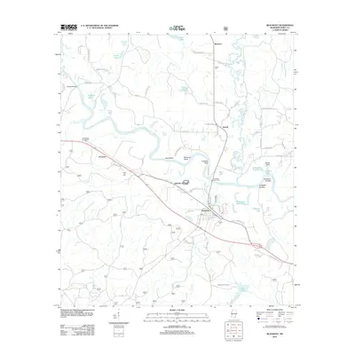
2012 Map of Beaumont
USGS Topo · Published 2012About this map
The Leaf River winds through Perry County in a complex series of meanders, defining the local geography with features like Racetrack Bend, Bland Bluff, and Fairhope Bluff. The town of Beaumont serves as a central hub for the area, where a grid of streets including Bradley Ave, Long St, and Baylis St meets the Leaf River Boat Ramp. The landscape is dotted with numerous oxbow lakes and backwaters such as Deitz Lake, American Legion Lake, and the uniquely named Lott Dead River, reflecting the shifting nature of the river over time.
Find a feature on this map
80 named features on this map. Tap any name to fly to it.
Don’t see what you’re looking for? This feature index may not catch every label — zoom into the map to look around manually.
Map Details
Editions of this 2012 Beaumont Map
This is the sole edition of this map. No revisions or reprints were ever made.
Other maps of this area

1947 · Beaumont
USGS Topo · 1:62,500

1947 · New Augusta
USGS Topo · 1:62,500

1949 · Beaumont
USGS Topo · 1:62,500

1949 · New Augusta
USGS Topo · 1:62,500

1953 · Hattiesburg
USGS Topo · 1:250,000

1958 · Hattiesburg
USGS Topo · 1:250,000

1963 · Brewer
USGS Topo · 1:24,000

1964 · Ovett SE
USGS Topo · 1:24,000

1964 · Richton
USGS Topo · 1:24,000
1982 · Neely
USGS Topo · 1:24,000