
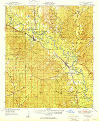
1949 Map of Beaumont
USGS Topo · Published 1949About this map
The Leaf River carves a winding path through this corner of southeast Mississippi, defining a landscape shaped by timber interests and rail transport. At the intersection of the Gulf Mobile and Ohio and the Bonhomie and Hattiesburg Southern railroads, Beaumont serves as a central hub for the surrounding pine forests. To the west, the Camp Shelby Military Reservation occupies a significant portion of the uplands, while the De Soto National Forest spans the southern reaches, highlighting the transition from military use to managed federal timberlands. The river's influence is evident in the numerous oxbows and named sandbars, such as Longfield Sandbar and Breakover Sandbar. Small, family-named locales like Kittrell, McLain, and Royce are scattered throughout, alongside landmarks such as the Beaumont Fire Tower and rural congregations like Moody Chapel, reflecting the area's mid-century settlement patterns.
Find a feature on this map
117 named features on this map. Tap any name to fly to it.
Don’t see what you’re looking for? This feature index may not catch every label — zoom into the map to look around manually.
Map Details
Editions of this 1949 Beaumont Map
2 editions found
Other maps of this area

1941 · Lucedale
USGS Topo · 1:62,500

1943 · Lucedale
USGS Topo · 1:62,500

1947 · Beaumont
USGS Topo · 1:62,500

1947 · Wiggins
USGS Topo · 1:62,500

1947 · New Augusta
USGS Topo · 1:62,500

1947 · Benndale
USGS Topo · 1:62,500

1949 · Wiggins
USGS Topo · 1:62,500

1949 · New Augusta
USGS Topo · 1:62,500

1949 · Benndale
USGS Topo · 1:62,500

1953 · Hattiesburg
USGS Topo · 1:250,000