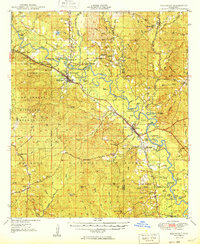
1949 Map of Beaumont
USGS Topo · Published 1949About this map
The Leaf River snakes through the heart of this post-war landscape, defining the geography of south-central Mississippi. Large portions of the territory are designated as the Camp Shelby Military Reservation and the De Soto National Forest, showing the significant federal footprint in the region during the late 1940s. The settlement of Beaumont serves as a vital rail junction, where the Gulf Mobile and Ohio and the Bonhomie and Hattiesburg Southern railroads intersect, facilitating the local timber and agricultural economy. Downstream, the town of McLain sits near the confluence of Thompson Creek and the river, surrounded by numerous dead-river lakes and sandbars like Longfield Sandbar. Genealogists will find a wealth of local landmarks, including several rural congregations such as Moody Chapel and Buffalo Ch, along with the McSwain Sch and family-named cemeteries like Sylvester Cem and Lott Cem.
Find a feature on this map
117 named features on this map. Tap any name to fly to it.
Don’t see what you’re looking for? This feature index may not catch every label — zoom into the map to look around manually.
Map Details
Editions of this 1949 Beaumont Map
2 editions found
Other maps of this area

1941 · Lucedale
USGS Topo · 1:62,500

1943 · Lucedale
USGS Topo · 1:62,500

1947 · Beaumont
USGS Topo · 1:62,500

1947 · Wiggins
USGS Topo · 1:62,500

1947 · New Augusta
USGS Topo · 1:62,500

1947 · Benndale
USGS Topo · 1:62,500

1949 · Wiggins
USGS Topo · 1:62,500

1949 · Beaumont
USGS Topo · 1:62,500

1949 · New Augusta
USGS Topo · 1:62,500

1949 · Benndale
USGS Topo · 1:62,500