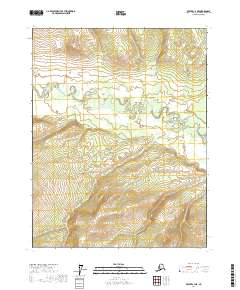
2017 Map of Beaver C-4 NE
USGS Topo · Published 2017About this map
The Hodzana River winds through this interior Alaskan wilderness, following a highly serpentine course across the northern reaches of the quadrangle. This 2017 study captures a landscape defined by dramatic elevation changes, with the river valley situated at approximately 700 feet while the surrounding hillsides in the southern sections rise toward 1,600 feet. The terrain is marked by intricate drainage patterns and oxbow features along the main river channel, illustrating the constant movement of the waterway through the valley floor. Aside from the river itself, the map is primarily a record of topographic relief and public land survey system divisions across the t22n r5w and t21n r5w townships.
Find a feature on this map
7 named features on this map. Tap any name to fly to it.
Don’t see what you’re looking for? This feature index may not catch every label — zoom into the map to look around manually.
Map Details
Editions of this 2017 Beaver C-4 NE Map
This is the sole edition of this map. No revisions or reprints were ever made.
Other maps of this area

1951 · Beaver
USGS Topo · 1:250,000

1956 · Beaver
USGS Topo · 1:250,000

1964 · Beaver
USGS Topo · 1:250,000
1970 · Beaver D-4
USGS Topo · 1:63,360
1970 · Beaver C-4
USGS Topo · 1:63,360
1990 · Beaver C-3
USGS Topo · 1:63,360
1990 · Beaver D-3
USGS Topo · 1:63,360
2017 · Beaver C-4 NW
USGS Topo · 1:25,000
2017 · Beaver D-3 SW
USGS Topo · 1:25,000
2017 · Beaver C-3 NW
USGS Topo · 1:25,000