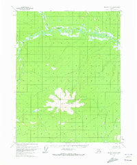
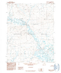
1970 Map of Beaver C-4
USGS Topo · Published 1973About this map
Lone Mountain dominates the central landscape of this interior Alaska survey, rising above a network of winding waterways and unsurveyed land lines. The Hodzana River snakes across the northern portion of the quadrangle, characterized by tight, recursive oxbow loops that indicate a slow-moving, mature river system through the valley. This 1970 aerial survey, published by the Geological Survey, documents a region largely devoid of permanent settlements, showing only a solitary Cabin near the confluence of Granite Fork. The topography is defined by the drainage basins of the Mud Fork and The East Fork, illustrating the complex hydrology of the Yukon-Koyukuk region before any significant modern development or road infrastructure reached this part of the Brooks Range foothills.
Find a feature on this map
9 named features on this map. Tap any name to fly to it.
Don’t see what you’re looking for? This feature index may not catch every label — zoom into the map to look around manually.
Map Details
Editions of this 1970 Beaver C-4 Map
This is the sole edition of this map. No revisions or reprints were ever made.
Other maps of this area

1951 · Beaver
USGS Topo · 1:250,000

1956 · Beaver B-3
USGS Topo · 1:63,360

1956 · Beaver B-5
USGS Topo · 1:63,360

1956 · Beaver
USGS Topo · 1:250,000

1956 · Beaver B-4
USGS Topo · 1:63,360

1964 · Beaver
USGS Topo · 1:250,000
1970 · Beaver D-5
USGS Topo · 1:63,360
1970 · Beaver C-5
USGS Topo · 1:63,360
1970 · Beaver D-4
USGS Topo · 1:63,360
1990 · Beaver C-3
USGS Topo · 1:63,360