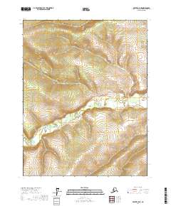
2017 Map of Beaver C-5 NE
USGS Topo · Published 2017About this map
Hodzana River winds through the interior landscape of the Yukon-Koyukuk region in this recent topographical study. The river enters the sheet from the northwest and snakes through the center-south, cutting across the survey lines of t22n r8w, t22n r7w, t21n r8w, and t21n r7w. This terrain is defined by a dense network of high ridges and narrow drainages, illustrating the complex geography of the Alaskan wilderness. In a region where formal infrastructure like roads and settlements are absent, the river serves as the primary geographic corridor through these remote townships.
Find a feature on this map
5 named features on this map. Tap any name to fly to it.
Don’t see what you’re looking for? This feature index may not catch every label — zoom into the map to look around manually.
Map Details
Editions of this 2017 Beaver C-5 NE Map
This is the sole edition of this map. No revisions or reprints were ever made.
Other maps of this area

1951 · Beaver
USGS Topo · 1:250,000

1956 · Beaver
USGS Topo · 1:250,000

1964 · Beaver
USGS Topo · 1:250,000
1970 · Beaver D-5
USGS Topo · 1:63,360
1970 · Beaver C-5
USGS Topo · 1:63,360
1970 · Beaver D-4
USGS Topo · 1:63,360
1970 · Beaver C-4
USGS Topo · 1:63,360
2017 · Beaver D-5 SE
USGS Topo · 1:25,000
2017 · Beaver D-5 SW
USGS Topo · 1:25,000
2017 · Beaver C-5 NW
USGS Topo · 1:25,000