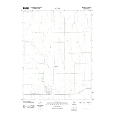
2011 Map of Beaver City
USGS Topo · Published 2011About this map
Beaver City serves as the focal point of this rural Furnas County landscape, organized around a rigid grid of agricultural roads like Road 711 and Road 427. The town's civic life is centered at the Beaver City Post Office and the Furnas County Fairground, while its recreational space is found at the Westside Park Campground on the western edge. This map reveals a community deeply tied to its water resources, with Beaver Creek meandering through the southern portion of the quadrangle. Several man-made structures regulate this flow, including the Furnas County Dam creating the Van Cleave Reservoir and the Theobald Dam forming the Theobald Reservoir. To the west of the town center, Mount Hope Cemetery provides a primary point of interest for genealogists, while the presence of Hewetts Airport to the north indicates the local infrastructure supporting this farming region.
Find a feature on this map
30 named features on this map. Tap any name to fly to it.
Don’t see what you’re looking for? This feature index may not catch every label — zoom into the map to look around manually.
Map Details
Editions of this 2011 Beaver City Map
This is the sole edition of this map. No revisions or reprints were ever made.
Other maps of this area

1896 · Arapahoe
USGS Topo · 1:125,000

1898 · Arapahoe
USGS Topo · 1:125,000

1955 · Grand Island
USGS Topo · 1:250,000

1957 · Grand Island
USGS Topo · 1:250,000
1957 · Beaver City SW
USGS Topo · 1:24,000

1957 · Precept
USGS Topo · 1:24,000

1957 · Beaver City SE
USGS Topo · 1:24,000

1958 · Grand Island
USGS Topo · 1:250,000

1958 · Edison
USGS Topo · 1:24,000

1958 · Hollinger
USGS Topo · 1:24,000