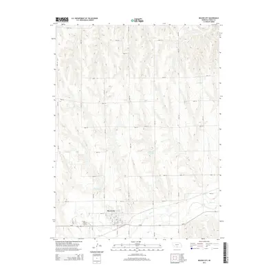
2014 Map of Beaver City
USGS Topo · Published 2014About this map
Beaver City serves as the focal point of this southwestern Nebraska landscape, where the town’s grid is clearly defined by named thoroughfares such as Count St, S St, and 12th St. The surrounding countryside is marked by a transition from the agricultural uplands down toward the winding course of Beaver Cr, which flows just south of the municipal center. This era of land management is reflected in local water resources like the Theobald Reservoir and Van Cleave Reservoir, both situated north of the city. Genealogists will find the exact location of Mt Hope Cem on the western edge of town, while researchers of rural infrastructure can trace the extensive network of section-line roads, including Road 714 and Road 427, that facilitate movement across the Furnas County terrain.
Find a feature on this map
37 named features on this map. Tap any name to fly to it.
Don’t see what you’re looking for? This feature index may not catch every label — zoom into the map to look around manually.
Map Details
Editions of this 2014 Beaver City Map
This is the sole edition of this map. No revisions or reprints were ever made.
Other maps of this area

1896 · Arapahoe
USGS Topo · 1:125,000

1898 · Arapahoe
USGS Topo · 1:125,000

1955 · Grand Island
USGS Topo · 1:250,000

1957 · Grand Island
USGS Topo · 1:250,000
1957 · Beaver City SW
USGS Topo · 1:24,000

1957 · Precept
USGS Topo · 1:24,000

1957 · Beaver City SE
USGS Topo · 1:24,000

1958 · Grand Island
USGS Topo · 1:250,000

1958 · Edison
USGS Topo · 1:24,000

1958 · Hollinger
USGS Topo · 1:24,000