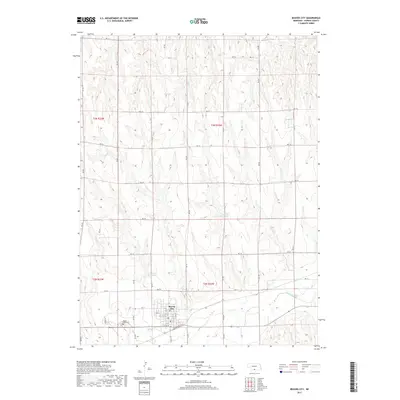
2017 Map of Beaver City
USGS Topo · Published 2017About this map
Beaver City serves as the central hub of this Nebraska plains landscape, where a dense grid of residential streets like Floyd St and Count St transitions abruptly into the surrounding agricultural sections. The town's layout, defined by lettered streets from M St to U St, reflects a classic Midwestern planning model centered on the south-flowing Beaver Cr. On the western outskirts, the Mount Hope Cem provides a significant touchstone for local genealogical research, marking the community's long-term presence in Furnas County.
Find a feature on this map
36 named features on this map. Tap any name to fly to it.
Don’t see what you’re looking for? This feature index may not catch every label — zoom into the map to look around manually.
Map Details
Editions of this 2017 Beaver City Map
This is the sole edition of this map. No revisions or reprints were ever made.
Other maps of this area

1896 · Arapahoe
USGS Topo · 1:125,000

1898 · Arapahoe
USGS Topo · 1:125,000

1955 · Grand Island
USGS Topo · 1:250,000

1957 · Grand Island
USGS Topo · 1:250,000
1957 · Beaver City SW
USGS Topo · 1:24,000

1957 · Precept
USGS Topo · 1:24,000

1957 · Beaver City SE
USGS Topo · 1:24,000

1958 · Grand Island
USGS Topo · 1:250,000

1958 · Edison
USGS Topo · 1:24,000

1958 · Hollinger
USGS Topo · 1:24,000