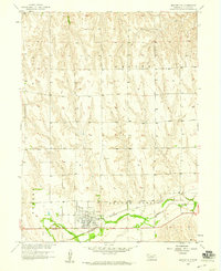
1958 Map of Beaver City
USGS Topo · Published 1959About this map
Beaver City serves as the focal point of this late 1950s survey, situated along the fertile valley of Beaver Creek. The town shows a developed grid with a prominent Fairground and local Park, reflecting its role as a regional hub in Furnas County. Transportation infrastructure is particularly dense here, featuring the Chicago Burlington and Quincy railroad line running parallel to the creek and a nearby Landing Field. On the western edge of the settlement, Mt Hope Cem provides a point of interest for genealogists tracing family histories in the Eureka and Beaver City districts. The surrounding landscape, divided into the Weaver and Eureka townships, is marked by the branching drainage patterns flowing into the main creek, with the Union Pacific line traversing the northern section of the map.
Find a feature on this map
13 named features on this map. Tap any name to fly to it.
Don’t see what you’re looking for? This feature index may not catch every label — zoom into the map to look around manually.
Map Details
Editions of this 1958 Beaver City Map
This is the sole edition of this map. No revisions or reprints were ever made.
Other maps of this area

1896 · Arapahoe
USGS Topo · 1:125,000

1898 · Arapahoe
USGS Topo · 1:125,000

1955 · Grand Island
USGS Topo · 1:250,000

1957 · Grand Island
USGS Topo · 1:250,000
1957 · Beaver City SW
USGS Topo · 1:24,000

1957 · Precept
USGS Topo · 1:24,000

1957 · Beaver City SE
USGS Topo · 1:24,000

1958 · Grand Island
USGS Topo · 1:250,000

1958 · Edison
USGS Topo · 1:24,000

1958 · Hollinger
USGS Topo · 1:24,000