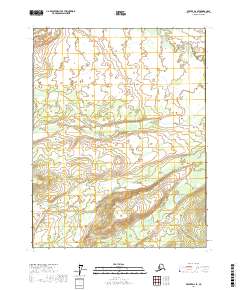
2017 Map of Beaver D-2 SE
USGS Topo · Published 2017About this map
The Hadweenzic River flows through the northern reaches of this territory, part of a complex watershed that drains the interior landscape north of the Yukon. The terrain is defined by a dense network of meandering streams with names derived from early distances or landmarks, such as Fortytwo Mile Cr and Forty-and-One-half Mile Cr. These numerical designations often hint at the proximity of historic trails or sled routes that once connected remote outposts. In the southeast corner, Fortymile Lake sits as a significant water body alongside Fortymile Cr. The map reveals a land largely untouched by modern road infrastructure, where the natural hydrography serves as the primary system of orientation for travel and subsistence.
Find a feature on this map
12 named features on this map. Tap any name to fly to it.
Don’t see what you’re looking for? This feature index may not catch every label — zoom into the map to look around manually.
Map Details
Editions of this 2017 Beaver D-2 SE Map
This is the sole edition of this map. No revisions or reprints were ever made.
Other maps of this area

1951 · Beaver
USGS Topo · 1:250,000

1956 · Beaver
USGS Topo · 1:250,000

1964 · Beaver
USGS Topo · 1:250,000
1990 · Beaver C-2
USGS Topo · 1:63,360
1990 · Beaver D-2
USGS Topo · 1:63,360
1990 · Beaver D-1
USGS Topo · 1:63,360
1990 · Beaver C-1
USGS Topo · 1:63,360
2017 · Beaver C-2 NE
USGS Topo · 1:25,000
2017 · Beaver C-1 NW
USGS Topo · 1:25,000
2017 · Beaver D-2 NE
USGS Topo · 1:25,000