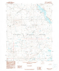
1990 Map of Beaver C-1
USGS Topo · Published 1990About this map
Yukon Flats dominate this landscape within the Yukon Flats National Wildlife Refuge, where a network of water and seasonal pathways defines human presence. The Hadweenzic River meanders through the northeast, carving a complex pattern of wetlands and channels typical of this subarctic basin. Settlement is limited to isolated structures connected by the Winter Trail, which provides critical transit across the low-lying terrain when the ground is frozen.
Find a feature on this map
12 named features on this map. Tap any name to fly to it.
Don’t see what you’re looking for? This feature index may not catch every label — zoom into the map to look around manually.
Map Details
Editions of this 1990 Beaver C-1 Map
This is the sole edition of this map. No revisions or reprints were ever made.
Other maps of this area

1951 · Fort Yukon
USGS Topo · 1:250,000

1951 · Beaver
USGS Topo · 1:250,000

1956 · Fort Yukon B-6
USGS Topo · 1:63,360

1956 · Beaver B-2
USGS Topo · 1:63,360

1956 · Beaver
USGS Topo · 1:250,000

1956 · Beaver B-1
USGS Topo · 1:63,360

1956 · Fort Yukon
USGS Topo · 1:250,000
1956 · Fort Yukon D-6
USGS Topo · 1:63,360
1956 · Fort Yukon C-6
USGS Topo · 1:63,360

1964 · Beaver
USGS Topo · 1:250,000