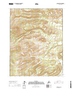
2017 Map of Beaver D-2 SW
USGS Topo · Published 2017About this map
Fortytwo Mile Cr winds through this interior Alaskan landscape, providing a primary drainage route for the high terrain in the Beaver D-2 SW quadrangle. The map captures the natural drainage patterns of the Yukon-Koyukuk region as they existed in the early 21st century. To the south, the water network includes the uniquely named Forty and One-half Mile Cr, which suggests an era of geographic naming tied to specific distances or trail milestones.
Find a feature on this map
8 named features on this map. Tap any name to fly to it.
Don’t see what you’re looking for? This feature index may not catch every label — zoom into the map to look around manually.
Map Details
Editions of this 2017 Beaver D-2 SW Map
This is the sole edition of this map. No revisions or reprints were ever made.
Other maps of this area

1951 · Beaver
USGS Topo · 1:250,000

1956 · Beaver
USGS Topo · 1:250,000

1964 · Beaver
USGS Topo · 1:250,000
1990 · Beaver C-2
USGS Topo · 1:63,360
1990 · Beaver D-2
USGS Topo · 1:63,360
1990 · Beaver C-3
USGS Topo · 1:63,360
1990 · Beaver D-3
USGS Topo · 1:63,360
2017 · Beaver D-3 SE
USGS Topo · 1:25,000
2017 · Beaver C-3 NE
USGS Topo · 1:25,000
2017 · Beaver C-2 NE
USGS Topo · 1:25,000