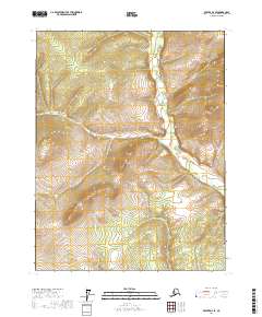
2017 Map of Beaver D-4 SE
USGS Topo · Published 2017About this map
Twin Sisters dominates the central topography of this Interior Alaska region, forming a prominent landmark above the winding waterways of the Yukon-Koyukuk region. The landscape is defined by the drainage patterns of the Pitka Fork Hodzana River, which meanders through the eastern sections of the quadrangle. Several tributaries, including Goldrun Cr, cut through the high-elevation terrain, illustrating the natural erosion patterns of the subarctic wilderness. The absence of roads or established settlements on this 2017 survey reflects the immense scale of the Alaskan bush, where navigation relies primarily on these distinct summits and watercourses. This document preserves the precise township and range boundaries across the t23n r5w and surrounding blocks, serving as a critical reference for understanding the land survey system in this unpopulated expanse.
Find a feature on this map
12 named features on this map. Tap any name to fly to it.
Don’t see what you’re looking for? This feature index may not catch every label — zoom into the map to look around manually.
Map Details
Editions of this 2017 Beaver D-4 SE Map
This is the sole edition of this map. No revisions or reprints were ever made.
Other maps of this area

1951 · Beaver
USGS Topo · 1:250,000

1956 · Beaver
USGS Topo · 1:250,000

1964 · Beaver
USGS Topo · 1:250,000
1970 · Beaver D-4
USGS Topo · 1:63,360
1970 · Beaver C-4
USGS Topo · 1:63,360
1990 · Beaver C-3
USGS Topo · 1:63,360
1990 · Beaver D-3
USGS Topo · 1:63,360
2017 · Beaver C-4 NW
USGS Topo · 1:25,000
2017 · Beaver D-3 SW
USGS Topo · 1:25,000
2017 · Beaver D-4 NW
USGS Topo · 1:25,000