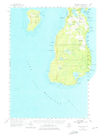
1956 Map of Beaver Island
USGS Topo · Published 1976About this map
The northern reaches of the Lake Michigan archipelago are defined by the remote settlements and shifting shoreline of the Beaver Island State Forest. This mid-century survey centers on the harbor town of St James, where the Beaver Harbor Lighthouse guards the entrance to Beaver Island Harbor. The interior landscape reveals a community transitioning away from earlier settlement patterns, evidenced by the presence of Sunnyside Sch (Abandoned) and Roseville Sch (Abandoned).
Find a feature on this map
52 named features on this map. Tap any name to fly to it.
Don’t see what you’re looking for? This feature index may not catch every label — zoom into the map to look around manually.
Map Details
Editions of this 1956 Beaver Island Map
2 editions found
Other maps of this area

1954 · Charlevoix
USGS Topo · 1:62,500

1955 · Hog Island
USGS Topo · 1:62,500

1955 · Gull Island
USGS Topo · 1:62,500

1955 · Cheboygan
USGS Topo · 1:250,000

1956 · South Fox Island
USGS Topo · 1:62,500

1956 · Beaver Island
USGS Topo · 1:62,500

1958 · Cheboygan
USGS Topo · 1:250,000
1980 · Garden Island West
USGS Topo · 1:24,000

1984 · Beaver Island
USGS Topo · 1:100,000

1984 · Charlevoix
USGS Topo · 1:100,000