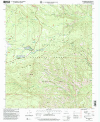
1997 Map of Beaverhead
USGS Topo · Published 2000About this map
Apache National Forest dominates this landscape in the late 1990s, revealing a complex network of high-elevation water management and livestock infrastructure. The small settlement of Beaverhead sits near the Beaverhead Natural Lake, serving as a focal point for activity in an area defined by steep drainages and prominent peaks. The presence of features like the Buckalou Corral and numerous tanks such as Tutt Tank and Josh Tank reflects the long-standing grazing operations within the Blue Range primitive area boundary.
Find a feature on this map
63 named features on this map. Tap any name to fly to it.
Don’t see what you’re looking for? This feature index may not catch every label — zoom into the map to look around manually.
Map Details
Editions of this 1997 Beaverhead Map
This is the sole edition of this map. No revisions or reprints were ever made.
Other maps of this area

1922 · Nutrioso
USGS Topo · 1:125,000

1954 · Clifton
USGS Topo · 1:250,000

1957 · Clifton
USGS Topo · 1:250,000

1958 · Clifton
USGS Topo · 1:250,000

1958 · Alpine
USGS Topo · 1:62,500

1958 · Hannagan Meadow
USGS Topo · 1:62,500

1958 · Big Lake
USGS Topo · 1:62,500

1961 · Blue
USGS Topo · 1:62,500

1962 · Clifton
USGS Topo · 1:250,000
1981 · Nutrioso
USGS Topo · 1:100,000