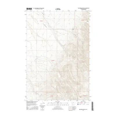
2017 Map of Beaverhead Rock SE
USGS Topo · Published 2017About this map
The Ruby Range dominates the southern reaches of this landscape, where the high terrain gives way to a network of drainage systems feeding the local basins. This 2017 survey details a remote area of Madison County primarily defined by its hydrography, with McHessor Cr and its tributaries, such as Trout Cr, carving distinct paths through the hills. The transition from high peaks to the valley floor is marked by features like Spring Canyon and the prominent Big Dry Gulch in the north. Human presence is sparse, confined largely to the winding path of McHessor Creek Rd and the Mc Hessor-Big Dry Gulch Rd, which follow the natural contours of the land. The mapping of Garden Cr and Spring Cr in the south provides a clear view of the water sources that have historically dictated land use and movement in this part of Montana.
Find a feature on this map
17 named features on this map. Tap any name to fly to it.
Don’t see what you’re looking for? This feature index may not catch every label — zoom into the map to look around manually.
Map Details
Editions of this 2017 Beaverhead Rock SE Map
This is the sole edition of this map. No revisions or reprints were ever made.
Other maps of this area

1893 · Dillon
USGS Topo · 1:250,000

1955 · Dillon
USGS Topo · 1:250,000

1957 · Dillon
USGS Topo · 1:250,000

1958 · Dillon
USGS Topo · 1:250,000

1961 · Mine Gulch
USGS Topo · 1:24,000

1961 · Christensen Ranch
USGS Topo · 1:24,000

1961 · Beaverhead Rock SE
USGS Topo · 1:24,000

1962 · Dillon
USGS Topo · 1:250,000
1962 · Beaverhead Rock
USGS Topo · 1:24,000
1962 · Beaverhead Rock SW
USGS Topo · 1:24,000