
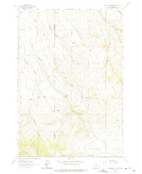
1961 Map of Christensen Ranch
USGS Topo · Published 1964About this map
Christensen Ranch and several family-named homesteads define this landscape along the border of Beaverhead and Madison counties. Surveyed in the early 1960s, the map reveals a remote ranching economy centered on scattered water sources and seasonal camps. Key landmarks like Bishop Place, Sorensen Ranch, and Guidici Cowcamp indicate a pattern of high-country land use where small outposts were maintained far from major towns.
Find a feature on this map
30 named features on this map. Tap any name to fly to it.
Don’t see what you’re looking for? This feature index may not catch every label — zoom into the map to look around manually.
Map Details
Editions of this 1961 Christensen Ranch Map
2 editions found
Other maps of this area

1893 · Dillon
USGS Topo · 1:250,000

1955 · Dillon
USGS Topo · 1:250,000

1957 · Dillon
USGS Topo · 1:250,000

1958 · Dillon
USGS Topo · 1:250,000

1961 · Mine Gulch
USGS Topo · 1:24,000

1961 · Glen SE
USGS Topo · 1:24,000

1961 · Red Canyon
USGS Topo · 1:24,000

1961 · Beaverhead Rock SE
USGS Topo · 1:24,000

1961 · Ashbough Canyon
USGS Topo · 1:24,000

1961 · Elk Gulch
USGS Topo · 1:24,000