
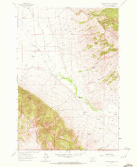
1961 Map of Ashbough Canyon
USGS Topo · Published 1965About this map
The Blacktail Mountains dominate the southwestern portion of this map, dropping sharply toward the winding valley of Blacktail Deer Creek. The landscape is defined by its ranching heritage, with several family-named outposts such as Rock Island Ranch and Landon Ranch scattered across the lower elevations. The intricate drainage network of the mountains is revealed through narrow cuts like Ashbough Canyon and Weston Canyon, which feed into the primary creek. A significant change in terrain is visible between the steep, forested slopes and the wide, open ranch lands to the north and east, illustrating how the geography dictated early settlement and land use. Small industrial indicators, including Borrow Pits, appear near the mountain base, while natural landmarks like Irishmans Hole suggest localized points of interest in an otherwise sparse, working landscape.
Find a feature on this map
20 named features on this map. Tap any name to fly to it.
Don’t see what you’re looking for? This feature index may not catch every label — zoom into the map to look around manually.
Map Details
Editions of this 1961 Ashbough Canyon Map
2 editions found
Other maps of this area

1893 · Dillon
USGS Topo · 1:250,000

1952 · Gallagher Mountain
USGS Topo · 1:24,000

1955 · Dubois
USGS Topo · 1:250,000

1955 · Dillon
USGS Topo · 1:250,000

1957 · Dillon
USGS Topo · 1:250,000

1958 · Dubois
USGS Topo · 1:250,000

1958 · Dillon
USGS Topo · 1:250,000

1961 · Christensen Ranch
USGS Topo · 1:24,000

1961 · Elk Gulch
USGS Topo · 1:24,000

1962 · Dillon
USGS Topo · 1:250,000