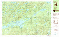
1989 Map of Beavers River
USGS Topo · Published 1989About this map
Stillwater Reservoir dominates the lower-left quadrant of this interior Adirondack Park survey, where the Beaver River settlement sits at the end of a long, isolated road network. The landscape is a dense network of water bodies and high peaks, including Clear Lake, Witchhopple Lake, and Mt Electra. This region of the North Country shows the infrastructure of seasonal residency and remote life, with small outposts like Norridgewock and Brandreth positioned along the Old Railroad Grade. This decommissioned rail line provides a clear historical trace of how loggers and travelers once accessed the remote central Adirondacks before modern vehicle travel became the primary mode of transit. Farther north, the map details the intricate shorelines of Nehasane Lake and Lila Lake, punctuated by landmarks such as Mosquito Island and Buck Island.
Find a feature on this map
68 named features on this map. Tap any name to fly to it.
Don’t see what you’re looking for? This feature index may not catch every label — zoom into the map to look around manually.
Map Details
Editions of this 1989 Beavers River Map
2 editions found
Other maps of this area

1903 · Big Moose
USGS Topo · 1:62,500

1903 · Raquette Lake
USGS Topo · 1:62,500

1907 · Tupper Lake
USGS Topo · 1:62,500

1912 · Number Four
USGS Topo · 1:62,500

1915 · Number Four
USGS Topo · 1:62,500

1916 · Oswegatchie
USGS Topo · 1:62,500

1918 · Oswegatchie
USGS Topo · 1:62,500

1919 · Cranberry Lake
USGS Topo · 1:62,500

1921 · Cranberry Lake
USGS Topo · 1:62,500

1931 · Cranberry Lake
USGS Topo · 1:62,500