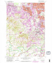
1984 Map of Beaverton
USGS Topo · Published 1985About this map
Beaverton and Tigard anchor this 1984 revision of the Tualatin Valley, documenting a period of rapid suburban intensification alongside long-established institutions. The map highlights significant land uses such as the St Marys Boys Home and the sprawling Tualatin Country Club. The transition from rural agriculture to residential development is evident in the purple-tinted urban updates, yet the landscape remains defined by its natural topography, including Bull Mountain and the low-lying Onion Flat near the Tualatin River.
Find a feature on this map
67 named features on this map. Tap any name to fly to it.
Don’t see what you’re looking for? This feature index may not catch every label — zoom into the map to look around manually.
Map Details
Editions of this 1984 Beaverton Map
This is the sole edition of this map. No revisions or reprints were ever made.
Other maps of this area

1897 · Portland
USGS Topo · 1:62,500

1905 · Portland
USGS Topo · 1:62,500

1914 · Oregon City
USGS Topo · 1:62,500

1915 · Hillsboro
USGS Topo · 1:62,500

1916 · Tualatin
USGS Topo · 1:62,500

1918 · Hillsboro
USGS Topo · 1:62,500

1939 · Oregon City
USGS Topo · 1:62,500

1939 · Tualatin
USGS Topo · 1:62,500

1940 · Tualatin
USGS Topo · 1:62,500

1940 · Hillsboro
USGS Topo · 1:62,500