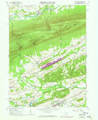
1965 Map of Beavertown
USGS Topo · Published 1973About this map
Bald Eagle State Forest and the ridgelines of Jacks Mountain dominate the northern terrain of this Snyder County landscape, where deep valleys like Henstep Valley contrast with the settled agricultural corridors to the south. The transition from timbered heights to the valley floor is marked by small rural communities such as Troxelville and Benfer. Further south, the borough of Beavertown sits near the Penn Central rail line, which tracks through a landscape defined by Thomas Ridge and Firestone Ridge. Cultural landmarks like Manbeck Ch and Cedar Hill Cem are documented alongside industrial and recreational sites, including a Claypit and Cameron Airport. The presence of a Covered Bridge over Middle Creek near the State Game Lands No 188 highlights the traditional infrastructure that persisted into the mid-20th century.
Find a feature on this map
62 named features on this map. Tap any name to fly to it.
Don’t see what you’re looking for? This feature index may not catch every label — zoom into the map to look around manually.
Map Details
Editions of this 1965 Beavertown Map
3 editions found
Other maps of this area

1907 · Millerstown
USGS Topo · 1:62,500

1925 · Mifflintown
USGS Topo · 1:48,000

1934 · Mifflintown
USGS Topo · 1:62,500

1937 · Mifflintown
USGS Topo · 1:62,500

1937 · Millheim
USGS Topo · 1:48,000

1938 · Mifflinburg
USGS Topo · 1:48,000

1941 · Millheim
USGS Topo · 1:62,500

1943 · Millerstown
USGS Topo · 1:62,500

1943 · Mifflinburg
USGS Topo · 1:62,500

1950 · Harrisburg
USGS Topo · 1:250,000
Featured Places
- Beavertown, PA
- Lewis Township, PA
- Laurel Park, Hartley Township
- Hartley Township, PA
- Franklin Township, PA