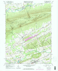
1965 Map of Beavertown
USGS Topo · Published 1973About this map
The ridge and valley terrain of central Pennsylvania dominates this landscape, where Jacks Mountain and Bald Eagle State Forest create a massive natural barrier between the northern and southern settlements. In the southern valley, the Penn Central rail line tracks alongside Middle Creek, connecting the established boroughs of Beavertown and Beaver Springs. This area shows a dense concentration of local heritage sites, including a Covered Bridge near the Corporate Boundary and several prominent houses of worship like Messiah Ch and St Peters Ch.
Find a feature on this map
54 named features on this map. Tap any name to fly to it.
Don’t see what you’re looking for? This feature index may not catch every label — zoom into the map to look around manually.
Map Details
Editions of this 1965 Beavertown Map
3 editions found
Other maps of this area

1907 · Millerstown
USGS Topo · 1:62,500

1925 · Mifflintown
USGS Topo · 1:48,000

1934 · Mifflintown
USGS Topo · 1:62,500

1937 · Mifflintown
USGS Topo · 1:62,500

1937 · Millheim
USGS Topo · 1:48,000

1938 · Mifflinburg
USGS Topo · 1:48,000

1941 · Millheim
USGS Topo · 1:62,500

1943 · Millerstown
USGS Topo · 1:62,500

1943 · Mifflinburg
USGS Topo · 1:62,500

1950 · Harrisburg
USGS Topo · 1:250,000
Featured Places
- Beavertown, PA
- Lewis Township, PA
- Laurel Park, Hartley Township
- Hartley Township, PA
- Franklin Township, PA