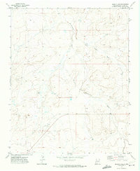
1970 Map of Becenti Lake
USGS Topo · Published 1974About this map
Kim-me-ni-oli Wash and Seven Lakes Wash converge in this high-desert region of McKinley County, defining a landscape shaped by seasonal drainage patterns. Surveyed in 1969 and 1970, the map illustrates the remote character of this arid terrain, punctuated by isolated water sources such as Becenti Lake and scattered Well sites. The presence of Ruins indicates long-standing human interaction with the environment, while modern resource exploration is evidenced by a Drill Hole and several benchmark elevations like BM 6488. The transition between T. 19 N. and T. 18 N. provides a cadastral framework for this segment of the Navajo Nation, where the rugged topography is documented through precise 20-foot contour intervals. This survey preserves a moment of rural New Mexico before extensive modernization, capturing the essential relationship between water access and settlement.
Find a feature on this map
9 named features on this map. Tap any name to fly to it.
Don’t see what you’re looking for? This feature index may not catch every label — zoom into the map to look around manually.
Map Details
Editions of this 1970 Becenti Lake Map
2 editions found
Other maps of this area

1883 · Mt. Taylor
USGS Topo · 1:250,000

1886 · Wingate
USGS Topo · 1:250,000

1886 · Mt. Taylor
USGS Topo · 1:250,000

1892 · Wingate
USGS Topo · 1:250,000

1892 · Mt. Taylor
USGS Topo · 1:250,000

1899 · Mt. Taylor
USGS Topo · 1:250,000

1954 · Gallup
USGS Topo · 1:250,000

1958 · Gallup
USGS Topo · 1:250,000

1958 · Albuquerque
USGS Topo · 1:250,000

1959 · Gallup
USGS Topo · 1:250,000